Warangal Urban District is located in the northern region of the Indian state of Telangana. The district headquarters are located at Hanamkonda.
Culture
Thousand Pillar Temple pond
Warangal Fort Ruins
In February 2013, Warangal was accorded World Heritage city status by UNESCO. A few tourist attractions include:
Warangal Fort
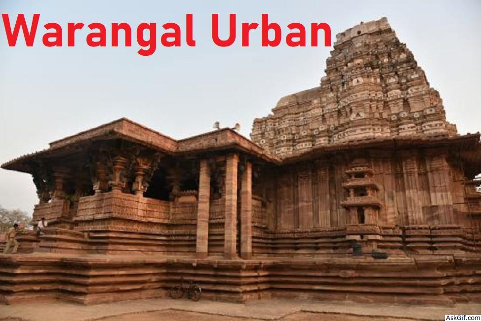
Thousand Pillar Temple
Padmakshi Temple
Bhadrakali Temple
A few of the notable personalities from the district include, Rudrama Devi, Kaloji Narayana Rao, Kothapalli Jayashankar, Nerella Venumadhav, and P. V. Narasimha Rao.
Transport
National Highway 163 (India) between Hyderabad – Bhopalpatnam of Chhattisgarh, National Highway 563 (India) between Jagitial-Khammam passes through the district. Warangal has two railway stations Kazipet Railway Station and Warangal Railway Station, which connects South and North India. The district has a small airport in Mamnoor, which can accommodate small aircraft like the ATR 42. This airport is currently used by police for gliding sorties, skeet shooting and aero-modeling.
Education
The schools in the district are under the administration of a District Education Officer controlled by Department of Education. Kashinath is the present Intermediate education officer, who oversees the junior colleges in the district for Telangana Board of Intermediate Education.
Some of the major educational institutions include, National Institute of Technology, Kakatiya Medical College, Kakatiya University, Kaloji Narayana Rao University of Health Sciences, University Arts and Science College, Kakatiya Institute of Technology and Science.
Geography
Warangal district occupies an area of 1,304.50 square kilometres (503.67 sq mi).
Demographics
As of 2011 Census of India, the district has a population of 1,135,707.
Administrative divisions
The district has only one revenue division i.e., Warangal and is sub-divided into 11 mandals. Prashanth J. Patil is the present collector of the district.
Mandals
S.No. Revenue Mandal
1 Bheemadevarpalli
2 Dharmasagar
3 Elkathurthy
4 Inavole
5 Hanamkonda
6 Hasanparthy
7 Kamalapur
8 Kazipet
9 Khila Warangal
10 Velair
11 Warangal
12 Kothapally
Economy
In 2006 the Indian government named Warangal one of the country's 250 most backward districts (out of a total of 640). It is one of the thirteen districts in Andhra Pradesh currently receiving funds from the Backward Regions Grant Fund Programme (BRGF).
History
Main article: Kakatiya dynasty
Warangal Rural district consists of many prehistoric habitation sites, which were explored by the Indian archaeological authorities. Paleolithic Rock art paintings are found at Pandavula gutta
Padmakshi Gutta, a Jain temple dedicated to Padmavati located on a hilltop in the heart of the town of Hanamkonda, was originally constructed during the Kakatiya era. The temple has sculptures of Jain tirthankaras and other Jain gods and goddesses. The Kadalalaya basadi or Padmakshi Temple is built on a large rocky outcrop.
The Kakatiyas left many monuments, including impressive fortress, four massive stone gateways, the Swayambhu temple dedicated to Shiva, and the Ramappa temple situated near Ramappa Lake. Prominent rulers included Ganapathi Deva, Prathapa Rudra, and Rudrama Devi. After the defeat of Pratapa Rudra, the Musunuri Nayaks united 72 Nayak chieftains and captured Warangal from Delhi sultanate and ruled for fifty years. Jealousy and mutual rivalry between Nayaks ultimately led to the downfall of Hindus in 1370 and the rise of the Bahmani Sultanate.
Formation of District
Undivided Warangal District from 1st Oct 1953 to 10th Oct 2016
During rule of Nizam of Hyderabad, State of Hyderabad was divided in many small Circars. Warangal was made as one the Circars in early 1800's. In 1866 Circars was Abolished and merged to create districts, Warangal district was created by merging Warungal, Khummettu and part of Bhonagheer circars. Jangaon area from Bhongir Circar was transferred to warangal and kamalpur area of warangal transferred to Karimnagra district. In 1905 when Princely state of Hyderabad sub divided into Four Division namely 1.Aurangabad Division, 2.Gulbarga Division, 3.Gulshanabad Division, 4.Warangal Division. During formation divisions again districts were delimited in 1905 Jangaon(Cherial) Taluka and Kodar(Kodad) Sub Taluka transferred to Nalgonda District from Warangal district. In 1905 AD, Warangal district was formed with Warangal, Pakala, Khammam, Yellandu, Mahabubabad, Madhira, Palvancha taluks and some area of old palvancha sanstan and some jagirs.This was bigger than many districts of Hyderabad state.
source: https://en.wikipedia.org/wiki/Warangal_Urban_district


