Viluppuram (also Villupuram or Vizhupuram) is one of the 37 districts that make up the state of Tamil Nadu, India. It was founded on 30 September 1993, prior to which it was part of the Cuddalore district district. Viluppuram district lies between the national highways of Tiruchirappalli and Chennai, and contains some historical landmarks, such as the Gingee Fort that is over 500 years old.
Viluppuram (also spelled as Villupuram and Vizhupuram) is a Municipality and the administrative headquarters of Viluppuram district, the largest district in the state of Tamil Nadu, India.
Located 61 kilometres (38 mi) south east of a Tiruvannamalai and 45 kilometres (28 mi) north west of Cuddalore. The city serves as a major railway junction, and National Highway 45 passes through it. With agriculture as its main source of income, As of Government of India 2014 data, Viluppuram had a population of 96253 and the city's literacy rate has been recorded as 90.16% by Census 2011.
Transport
Main article: Transport in Viluppuram
Road
Viluppuram is connected by roads to major cities and to the rest of the state. The major national highways of the town are:
NH 45, which connects Chennai to Theni, via Viluppuram – Tiruchirapalli – Dindigul – Periyakulam.
NH 45A, which connects Viluppuram to Nagapattinam via Pondicherry and Cuddalore.
NH 234, which Connects Villupuram to Mangalore via Thiruvannamalai – Vellore – Gudiyatham.
NH 45C, which connects (Viluppuram) Vikravandi to Thanjavur via Panruti – Neyveli – Kumbakonam and intersects with NH 45A in Koliyanur, about 3 km from Viluppuram.
Rail
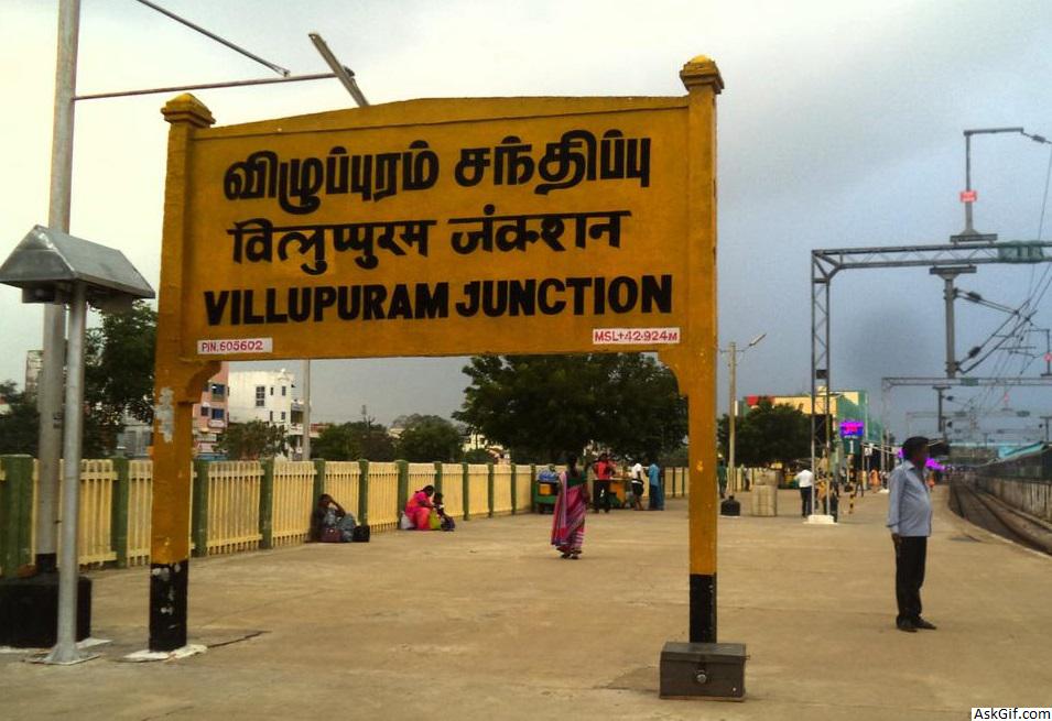
Viluppuram Railway Junction
Viluppuram has a railway station. It was first built under the British. The Viluppuram Railway Junction at Viluppuram serves as the distribution point of rail traffic from Chennai, the state capital of Tamil Nadu, towards the southern part of the state. It is one of the important junctions in Southern Railway. Five railway lines branch out of Viluppuram:
Fully Electrified Double BG (Broad Gauge) line (FEDL) towards Chennai Beach via Chengulpattu Junction.
Fully Electrified Double BG (Broad Gauge) line (FEDL) towards Tiruchirapalli Junction via Vridhachalam Junction and Ariyalur. Also called "Chord Line" to Tiruchirapalli.
Non electrified BG (Broad Gauge) line towards Tiruchirapalli Junction via Cuddalore Port Junction, Mayiladuthurai Junction, Kumbakonam and Thanjavur Junction.Also called Main Line.
Electrified BG (Broad Gauge) line towards Katpadi Junction via Tiruvannamalai and Vellore Cantonment.
Electrified BG (Broad Gauge) line to Pondicherry.
Air
The nearest airport is Pondicherry Airport at Pondicherry, in Puducherry, approximately 40 km from Viluppuram. Pondicherry Airport is connected to Bangalore by commercial airlines.
The nearest major airport is the Chennai International Airport (MAA), approximately 147 km from the town; the next closest major airport is Tiruchirapalli Airport, approximately 170 km from the town.
In 1919, Viluppuram was officially constituted as a municipality, which today comprises 42 wards, making it the largest town and municipality in Viluppuram district.
Taluks
Viluppuram district has 13 taluks.
Viluppuram
Tindivanam
Vikravandi
Vanur
Gingee
Marakkanam
Melmalayanur
Kandachipuram
History
Viluppuram district was once a part of the South Arcot district along with the Cuddalore district. Later, Cuddalore district was bifurcated and Viluppuram district came into existence on 30 September 1993. As a result, the Viluppuram district's history closely resembles that of Cuddalore's.
The Cholas were among the earliest rulers. Karikala Chola was the most influential. Simhavishnu Pallava overthrew the Cholas, and the region came under the Pallava rule. Vijayalaya Chola restored the rule of Chola, marking the beginning of the Chola Empire.
In 1677, Shivaji overtook the Gingee area with the help of Golkonda forces. Then came the reign of the Mughals, which is when the English and French acquired settlements in South Arcot District. The entire district became a war zone during the Anglo-French rivalry and it came under the control of the East India Company. It remained under British authority until the independence of India in 1947.
On January 2019, Kallakurichi district was carved out of Villupram.
Geography
The district shares borders with Bay of Bengal in the east, Puducherry district of the union territory Puducherry in the southeast and the districts Chengalpattu and Tiruvannamalai in the north, Cuddalore in the south and Kallakurichi in the west.
source: https://en.wikipedia.org/wiki/Viluppuram_district


