Tonk is a town in the Indian state of Rajasthan. The town is situated 95 km (60 mi) by road south from Jaipur, near the right bank of the Banas River. It is the administrative headquarters of Tonk District. Tonk was also the capital of the eponymous princely state of British India from 1817 to 1947.
Tonk District is a district of the state of Rajasthan in western India. The city of Tonk is the administrative headquarters of the district. The district is bounded on the north by Jaipur district, on the east by Sawai Madhopur district, on the southeast by Kota district, on the south by Bundi district, on the southwest by Bhilwara district, and on the west by Ajmer district.
Geography
18. Location in Rajasthan
Tonk is on National Highway 12, 100 km from Jaipur. It is in the northeastern part of the state between 75.19' and 76.16 East longitude and 25.41' and 26.24' North latitude. The total area is 7194 km2 (as per 2002-03).
It is one of the four districts headquarters of Rajasthan state that are not directly connected with rail. The nearest railway station, Newai, is within the district but is 30 km from the district headquarters. Banas River flows through the district.
Economy
In 2006, the Ministry of Panchayati Raj named Tonk one of the country's 250 most backward districts (out of 640). It is one of the 12 districts in Rajasthan receiving funds from the Backward Regions Grant Fund (BRGF).
Most of the population depends on agriculture.
Divisions
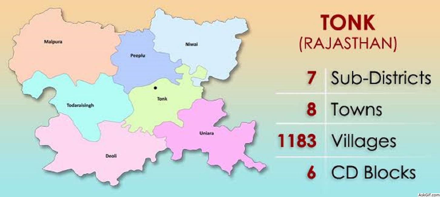
There are seven sub-divisions and tehsils: Deoli, Malpura, Newai, Todaraisingh, Tonk, Uniara and Peeplu. Tonk is Nagar-Parishad while Deoli, Malpura, Newai, Todaraisingh and Uniara are Nagar-Palikas. There were 1093 villages in the district according to the 2001 census.
Demographics
According to the 2011 census, Tonk district has a population of 1,421,711, roughly equal to the nation of Swaziland or the US state of Hawaii. This gives it a ranking of 347th in India (out of 640). The district has a population density of 198 inhabitants per square kilometre (510/sq mi). Its population growth rate over the decade 2001-2011 was 17.33%. Tonk has a sex ratio of 949 females for every 1000 males and a literacy rate of 62.46%.
At the time of the 2011 Census of India, 95.82% of the population in the district spoke Hindi and 3.81% Urdu as their first language.
Culture
Pilgrimage sites
Dadabadi temple
History
The founder of the state was Nawab Muhammad Amir Khan (1769-1834), an adventurer and military leader of Pashtun descent from Afghanistan. Amir Khan rose to be a military commander . In 1806, Khan received the state of Tonk from British Government. In 1817, after the Third Anglo-Maratha War, Amir Khan submitted to the British British East India Company, he kept his territory of Tonk and received the title of Nawab.
During the regime of Nawabs, the natives were invited to an Islamic function of Milad-un-nabi without regard to caste, color or creed. It was organised by the ruling Nawabs for a period of seven days in the month of Rabi al-awwal.
The founding ruler of Tonk was Nawab Muhammad Amir Khan (1769-1834). Tonk was known as Samwad Lakshya in the Mahabharat period. In the Mauryan regime, it was under the Mouryas and then it was merged into Malvas. Most of the period was under Harsh Vardhan. According to Huen Tsang, visitor to China, it was under Bairath State. In the regime of the Rajputs, this state was under, Solankis of Toda and later Kachvahs took over when Man Singh defeated the Rao of Toda . Later, it was under the regime of Holkar and Sindhia.
In 1806, Amir Khan conquered it, taking it from Yashwant Rao Holkar. The British government captured it in turn. Under the treaty of 1817, the British government returned it to Amir Khan. Tonk was founded in 1818 by an Afghan military leader who was granted land by the ruler of Indore.
source: https://en.wikipedia.org/wiki/Tonk,_India


