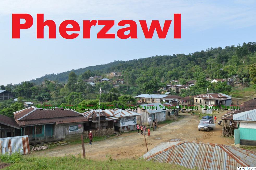
Pherzawl is a district of Manipur state in India.
Pherzawl village is the headquarter of the Pherzawl District of Manipur, India. Pherzawl district was created by bifurcating Churachandpur district..
Pherzawl is also the Sub-Divisional headquarter of Pherzawl Sub-Division, one of the four sub-divisional blocks of the district.
Location and politics
Pherzawl District is located in the southern part of the state of Manipur. It is bounded on the east by Churachandpur District; on the north by Tamenglong District and Jiribam district; on the west by the Cachar District of Assam and on the South by Sinlung Hills, Mizoram. Pherzawl District is located between 93° 11' 16.0440' East Longitude and 24° 15' 43.0524' North Latitude and is in the southern part of Manipur state. Pherzawl District has approximately 200 villages, according to the government's record.
The Pherzawl District came into existence on 8 December 2016 by joining 55-AC Tipaimukh (ST) and 56-AC Thanlon (ST) with its headquarters at Pherzawl. Despite the controversy surrounding the creation of seven new revenue districts in Manipur, the people of Pherzawl District welcomed the decision with celebrations on 16 December 2016, when Manipur Chief Minister O.Ibobi Singh inaugurated the administrative centre at Pherzawl village.
Transport
Pherzawl is connected with the state capital Imphal via roads. A bus service running between Imphal and Pherzawl began in 2017.
Climate and geography
The district is under humid subtropical climate. The soil is moderately fertile with clay loam soil with little patches of clay and loam. The temperature ranges from a minimum of 3.4 °C (38.1 °F) to a maximum of 34.1 °C (93.4 °F). The annual rainfall ranges from 670 to 1,450 mm (26 to 57 in). The elevation of the District is 1037 meters, or 3,402 feet.
About 80% of the land area is covered by forest while the remaining 20% is utilized for cultivation. Rice, Maize and Ginger are the district's major crops. Agriculture is the main occupation of the people.
Administrative divisions
The district is divided into 4 sub-divisions:
Pherzawl Sub-Division
Parbung Sub-Division
Thanlon Sub-Division
Vangai Range Sub-Division
Villages list
Vangai subdivision
Ankhasuo(Sibapurkhal)
Buongmun
Chingmun
Dawltang
Henchungpunjee
Jakrador(Phaimuol)
Jeisuo
Kangreng
Kangrengdhor
Kasurvali
Kh. Jeikhan
Khangbor
Lower Kharkhuplien
Moinador(Hmarkhothar)
Muolkhangthol
Ngampabung
Nungsekpunjee
Patpuihmun
Phaibok Munlien
Phaibok Munte
Phailien
Phailienthang Punjee
Phulpui
Saikulphai
Sartuinek
Savomphai
Suongphuhmun
Thingkal
Thingkaldhor
Thingpuikuol
Tieulien
Tuaitengmun
Tuisen
Upper Kharkhuplien
Vangai
Parbung subdivision
Damdei
H.maulien
Leisen
Loibuol
Lungthulien
New Talan
Parbung
Parvachawm
Pherzawl
Rovakot
Senvon
Serhmun (leisen Machet)
Sipuikon
Taithu
Talan (pherzawl Machet)
Thingpan
Tinsuong
Tipaimukh
Tuolbung
Pherzawl and Thanlon subdivisions
Aibulon
B.munpi
Bualmual
Bualtang
Bukpi/zoupi
Bungjang
Bungpilon
C. Zalen
Dailon
Dialkhai
Galkapkot
Gamhui
Hanship
Kaihlam
Khajang
Khoken
Khuanggin
L.Phungchongjang
Leijangphai
Maite
Milongmun
Mong-on
Mualhoih Ching
Mualkui
Mualnuam
Mualpheng
Muikawt
Muntha/T. Phaikholum
Nahthialbok
Paikholun J.
Parkhuong
Pamzal
Pangen
Phaijang
Phailianbung
Phainuam
Phaipheng
Phaitong
Sainoujang
Saite
Savaiphai
Sinzang
Sinzawl
Songtal
Suongpekhmun
Suongsang
Sumtuh
Tallian
Tangnuam
Thlanlawn
Thiekbung
Thenjol
Thuangtam
Tuikumuallum
Tuilileibul/ Tuilijang
Tuipiphai
Umtal
Vaipheimual
Zoutung
Jiribam subdivision
Joironpokpi Village
Muolzawl
Soma Punjee (Gilgal
Tuisuolien(Kaia Punjee)
B. Huonveng
Buthangkhal
Bekarasuo (Kaisel Punjee)
Dolakhal (Zamkham Punji)
Kotoikhal (Thangboi Punjee)
Chowdhurikhal
Mongbung Village
Sejang Village
Leisabithol Village
Literacy
The literacy rate in Pherzawl District is 79%. 37,328 out of total 47,250 population are educated here. Among males the literacy rate is 83.5% as 19,961 males out of total 23,906 are literate while female literacy rate is 76% as 17,747 out of total 23,353 females are literate. The main language spoken is Hmar Simte Paite and Thadou.
source: https://en.wikipedia.org/wiki/Pherzawl_district


