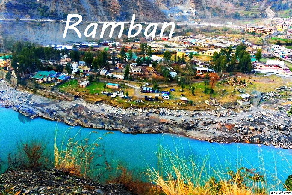
Ramban is a town in the Ramban district in Indian state of Jammu and Kashmir. It is the district headquarters. It lies on the banks of the Chenab river, on the National Highway-1A (now NH44) at about 150 km from Jammu and about 150 km from Srinagar, making it almost the central point on the Jammu-Srinagar National Highway.
Ramban is one of the 22 districts in the state of Jammu and Kashmir, India. Ramban is located in the lap of Pir Panjal range of the mighty Himalayas. It was carved out of erstwhile Doda District keeping in view the backwardness, remoteness and aspiration of people of the area. District Ramban started functioning as independent unit on 1 April 2007. Ramban town is the district headquarters. The town is located midway between Jammu and Srinagar along the Chenab river, on National Highway-44, (originally National Highway 1A (India)) approximately 150 km from Jammu and Srinagar.
Gajpat Fort
There is an important fort known as Gajpat Fort, on the top of mountain. It is said that once Sheikh Abdullah was kept imprisoned in this fort for few days. In 1825, Gulab Singh had imprisoned Raja Sultan Khan of Bimbar in this fort. Sultan Khan died there and was buried at Chanderkote. In 1858 Mean Hathu Singh, the Governor of Rajouri and a closed relatives of Maharaja had revolted against State Government and tried to kill Maharaja Ranbir Singh. Mean Hathu was arrested and shifted to Gajpat fort.
Tourist Attractions
Sanasar
Sanasar Lake
Tourist activities Sanasar include paragliding, hot air ballooning, trekking, camping, golf, rock climbing and abseiling.
Tata-Pani
Tata-Pani hot spring is located near Sangaldan, Ramban.
Pastures and meadows
Daggan Top (Gool)
Chamsar Top (Ramban )
Shinkli Top (Ramban)
Ranjati (Gool)
Ramakunda (Gool)
Tanj Maidan (Banihal)
Zaban (Banihal)
Brahru ( Ramban)
Shainshi ( Ramban)
Marg ( Banihal )
Shirthtathi( Banihal )
The Hill station of nowgam Valley North Banihal
Origin of Bishliri Nallah
Historical Sheep breeding farm(1932) is situated at Zaban
Sanasar (Ramban)
Shakhpal Hill (Ramban)
Thandichowa (Banihal)
Mohu and Mangit (Banihal)
Major projects
Baglihar Dam
Pir Panjal Railway Tunnel
Banihal Qazigund Road Tunnel
Chenani-Nashri Tunnel
Administration
Ramban District is divided into eight tehsils: Banihal, Ramban, Khari, Rajgarh, Batote, Gool, Pogal Paristan (Ukhral) and Ramsoo.
Each tehsil has its tehsildar, who is the administrative head. The district consisted of 116 census villages and 127 revenue villages in 2001. The total number of panchayat Halqas in the district was 124.
Geography
Ramban district is 1,156 metres (3,792 feet) above sea level (on average). The boundary lines of Ramban district encompass hill station Patnitop as its southernmost point, Assar on its eastern edge, Gool to the west, and Banihal to the north. Terrain of district Ramban is tough and hilly. District Ramban shares its boundary with Reasi, Udhampur, Doda, Anantnag and Kulgam.
Climate
The climate of the District varies according to altitude. The temperature rises as high as 42 °C in the low-lying areas like Ramban town located in between steep Mountains on the banks of river Chenab and drops to sub zero in the high altitude areas like Sangaldan,Gool, Dhagantop, Asthanmarg,Lalagundi, Budhan. The working season in most of the district is about eight months because of typical weather conditions in the district.
Politics
Ramban district has three assembly constituencies: Ramban, Banihal and Gool.
Demographics
According to the 2011 census, Ramban district has a population of 283,713. roughly equal to the nation of Barbados. This gives it a ranking of 573rd in India (out of a total of 640). The district has a population density of 213 inhabitants per square kilometre (550/sq mi) . Its population growth rate over the decade 2001-2011 was 31.81%. Ramban has a sex ratio of 901 females for every 1000 males, and a literacy rate of 54.27%.
Kashmiri and its dialects (Poguli and Sirazi) is the most widely spoken language in the district. The other languages spoken here are Urdu, Punjabi, Dogri, and Gojri. Ramban has a Muslim majority, with Muslims constituting about 70% and Hindus constituting about 28% of the population.
source: https://en.wikipedia.org/wiki/Ramban_district


