West Kameng is a district of Arunachal Pradesh in northeastern India. It accounts for 8.86% of the total area of the state. The name is derived from the Kameng river, a tributary of the Brahmaputra, that flows through the district.
History
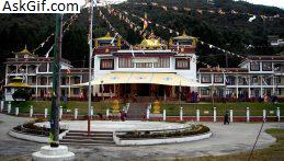
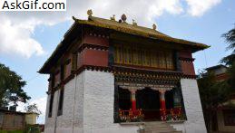
The area around the Kameng river has traditionally come under the control of the Mon kingdom, Bhutan, Tibet and the Ahom kingdom. Lamaism got a strong foothold among the tribal groups as early as in the 7th century, where the Kachen Lama constructed the Lhagyala Gompa in Morshing.
Whenever loose control was exerted over the area, small, feudal chiefdoms ruled by the Miji and the Aka chiefs dominated control over the area. This can be evidenced in the fact that ruined fortresses like those in Bhalukpong constructed in the 10th to 12th century and the Dirang fort, which was constructed in the 17th century to defend against invasions from neighbouring chiefdoms.
Upon the arrival of the British, the entire area became what was known as the North-East Frontier Agency. It was renamed as the Balipara Frontier tract in 1919, with its headquarters at Charduar in Assam. In 1946, the district area was carved out of the Balipara, with the name Sela Sub-Agency and its headquarters continued to be Charduar of Assam.
Geography
West Kameng district occupies an area of 7,442 square kilometres (2,873 sq mi), comparatively equivalent to Papua New Guinea's New Ireland. It lies approximately between 91° 30' to 92° 40' East longitudes and 26° 54' to 28° 01' North latitudes. The district shares an international border with Tibet in the north, Bhutan in the west, Tawang District in the northwest, and East Kameng district in the east. The southern border is shared with Sonitpur district and Udalguri district of Assam. The Eaglenest Wildlife Sanctuary is located in West Kameng.
Topography
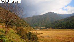
The topography is mostly mountainous. Much of West Kameng area is covered with the Himalayas. The highest peak in the district and state is Kangte.
Climate
Like East Kameng, the West Kameng district experiences an arid tundra or a cool temperate climate in the north. Snow fall occurs from mid-November to February. Snow can be also seen in Khupi, Bomdilla, Nechiphu. Nechiphu is the highest place in the district, situated at 5690 feet above sea level.
Transport
The 2,000-kilometre-long (1,200 mi) proposed Mago-Thingbu to Vijaynagar Arunachal Pradesh Frontier Highway along the McMahon Line, (will intersect with the proposed East-West Industrial Corridor Highway) and will pass through this district, alignment map of which can be seen here and here.
Divisions
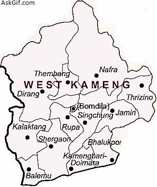
The district is divided into three subdivisions, Thrizino, Rupa and Bomdila, which are further divided into twelve administrative circles, namely, Dirang, Bomdila, Kalaktang, Balemu, Bhalukpong, Jameri, Sinchung, Nafra, Thrizino, Rupa, Thembang and Shergaon. The four development blocks in this district are Dirang, Kalaktang, Nafra-Buragaon, and Thrizino.
There are 4 Arunachal Pradesh Legislative Assembly constituencies located in this district: Dirang, Kalaktang, Thrizino-Buragaon and Bomdila. All of these are part of Arunachal West Lok Sabha constituency.
Demographics
Population
According to the 2011 census West Kameng district has a population of 87,013, roughly equal to the nation of Antigua and Barbuda. This gives it a ranking of 618th in India (out of a total of 640). The district has a population density of 12 inhabitants per square kilometre (31/sq mi) . Its population growth rate over the decade 2001–2011 was 16.64%. West Kameng has a sex ratio of 755 females for every 1000 males, and a literacy rate of 69.4%.
Language
West Kameng comprises five major tribes: Monpa (which includes Dirang, Bhut, Lish, and Kalaktang Monpa), Miji (Sajolang), Sherdukpen, Aka (Hrusso), and Bugun (Khowa). Minority tribes include Takpa, Lishipa, Chugpa, and Butpa. All of these indigenous communities use the Nefamese language (an Assamese pidgin) to communicate with each other.
Languages spoken in West Kameng include the following.
Puroik language
Hruso language (Aka)
Miji language
Kho-Bwa languages
Khowa language (Bugun)
Sherdukpen language
Sartang language
Lish language (and Chug)
Bodish languages
Brokpa language
Tshangla language
Religion
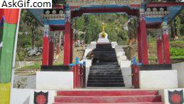
Most of the inhabitants are Buddhist, though the Aka, Khowa, and Miji have indigenous religions and those tribe members follow a mix of Buddhism, Hinduism, and Donyi-Polo (a form of Animism).
Flora and fauna
In 1989 West Kameng district became home to the Eaglenest Wildlife Sanctuary, which has an area of 217 km2 (83.8 sq mi). It is also home to the Sessa Orchid Wildlife Sanctuary, which was established in 1989 and has an area of 100 km2 (38.6 sq mi).
source: https://en.wikipedia.org/wiki/West_Kameng_district